 |
SLOP explanation Video |
Flying the Atlantic Ocean
Every day hundreds of aircraft fly East and West across the Atlantic Ocean from Europe to Canada and the USA. Add traffic heading North and South to and from and overflying Greenland and Iceland through the Oceanic Control Areas It is a massive feat consideration there is no radar in the Atlantic no mid air collisions occur. In this lecture I am going to give you a very basic outline of how this system works so you as a Virtual Airline Pilot will get a good understanding. Basically each day in summer about 120 aircraft every hour enter the Atlantic Ocean on a crossing. The main system works as follow:-
The day before the weather reports are looked at and the airlines give in advance the routes they want to fly. From their route suggestions the Oceanic Air Traffic Control Centres coordinate with each other and a set of tracks are designed to avoid headwinds where possible and to use tailwinds. Approximately 6 tracks per day are designed each which always start and finish at same 5 or 6 oceanic entry points either side of the Atlantic each day. The tracks for the following day are published at 2200 hours.
Normally Westbound tracks from Europe are during the day opening around 1130 hours UTC time until 1930 UTC and 0100 UTC to 0800 UTC on the North American side coming East to Europe. Other flights and routes must be agreed with Oceanic Control. The first rule is no aircraft are allowed to enter the Oceanic Control Area without a an oceanic clearance. Pilots must obtain clearance at least 30 minutes before arriving at the Oceanic Entry Point. This means that some pilots have to contact the Oceanic Control Centre by telephone or data link before take off if the entry point is a short flight to the boundary. (Ie Dublin, Glasgow and Belfast ).
Pilots on booking on duty will check all the published tracks onto a plotting chart and work out what is the best one for them on the day. They also work out what the best height for the crossing will be. It does not mean they will get the track they want nor the height they want to cruise at. They request it and the Oceanic Control Centers will check it. It maybe they can offer the aircraft the same track at a different height or a different track at the same height so some negotiation between pilots at Oceanic does go on. This is often done in the air on the frequency. For two engine aircraft ETOPS procedures have to be followed as the aircraft must always stay within its airlines time allocation.. A separate lecture on this is provided.. To cross the Atlantic an Airline must have at least 137 mins approved ETOP time. Failing that it must route close to Iceland and Greenland. The pilots must not accept a track that takes them outside the company ETOPS time. The reason the Oceanic Control may not be able to give the pilots the track they want is because another aircraft is at that height within 10 minutes on the same track. Oceanic will offer pilots the best options. Clearances must be read back and cruise speed must be adhered to as well as the cleared flight level.
SLOP Procedure
Pilots may fly on the centre line of the track or one mile to the right or two miles to the right of the centre line on the route across. At the exit fix they must be on the centre line for ATC separation purposes. The pilot does not need to get permission for this. This is useful due to the fact you may have an aircraft overtake you on the same track higher than you and you get the aircrafts dirty air vortex wake or you may get one above at the same speed just in front. This two miles can get you out of the wake of the other aircraft. Lets take a look at the tracks in more detail now. Pilots must not climb or descend when in the track structure unless in an emergency and procedures apply to do this. They may divert to the right around weather say 20 miles but again with safeguards. They climb or descend 300 FT if they have to do this until they are back on 1,2 or centre line of the track. Pilots are encouraged to fly one or two miles off track centre line as with the accuracy of navigation equipment it lessens the chance of collision if aircraft are staggered and an aircraft accidentally leaves s off the cleared cruise level.
|
SLOP explanation Video |
Lets now look at the track structure in detail. from space and how aircraft are seperated.
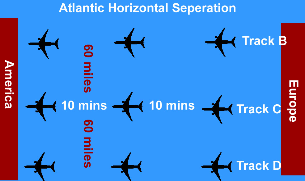
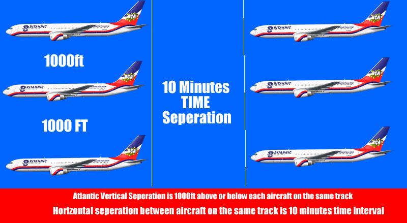
Horizontally the aircraft on the same track are separated 60 miles apart to the left and right of the aircraft on the next available track and and 10 minutes time interval in front and behind at the same cruise flight level. The aircraft above and below in vertical separation must be at least 1000 ft. ATC work this out mathematically and monitor this using weather reports. Pilots make position reports and give time estimates to Air Traffic Control at designated track waypoints so ATC can monitor and keep a check the aircraft are not closing in at. Pilots do not talk directly to Air Traffic Controllers in the Atlantic they talk to Radio Operators who pass the messages onto to the Air Traffic Controllers and messages from Air Traffic Controllers go through Radio Operators to to pilots for HF radio Selcal facility which is works like a telephone on the aircraft in simple terms. Each aircraft has its own selcal code. FMC datalink equipment is also in use .
Same Track Seperation
As stated a set of Entry and Exit points run North to South at each side of the Atlantic this is where the countries landfall route networks starts. When the pilots come within VHF radio range at the exit point they are then given their onward routes clearance to destination via the routes ATC give after checking the flow management computers. In Europe these routes are preferred routes as indicated by the Route Availability Documents RAD. Slot times are not issued inbound to Europe as the aircraft is coming anyway its the Europe domestic traffic that gets delayed if the Atlantic de;layed traffic enters UK airspace late morning.
Lets now look at a set of tracks in more detail. for a day
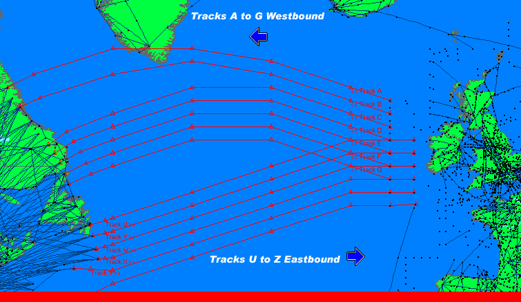
The oceanic waypoints are longitude and latitude coordinates such as 50north 10 West 50 north 15 west etc.indicated by the triangles. If you look at the eastbound the tracks that look as if they are converging in fact do not as buy the time the aircraft route from North America and arrive in the area those portions of tracks going West are not in operation. Likewise the tracks would not be operational for traffic coming east at the time the westbound airports leave Europe. Westbound tracks are normally daytime and Eastbound tracks are night times.
Below is part of the westbound tracks list in text forms for the map above showing flight levels available. These tracks are open from 1130 hours.
NAT-1/3 TRACKS FLS 310/390 INCLUSIVE JUN 21/1130Z TO JUN 21/1900Z PART ONE OF THREE PARTS- A BALIX 61/20 62/30 62/40 61/50 60/60 PEPKI LOPVI EAST LVLS NIL WEST LVLS 310 320 330 350 360 370 EUR RTS WEST NINEX NAR N464E N468E N472E N474E- B ERAKA 60/20 61/30 61/40 60/50 59/60 LAKES EAST LVLS NIL WEST LVLS 310 320 330 350 360 370 EUR RTS WEST ETSOM NAR N414C N424E N428C N432B N434C N436A- C GOMUP 59/20 60/30 60/40 59/50 PRAWN YDP EAST LVLS NIL WEST LVLS 310 320 330 350 360 370 380 390 EUR RTS WEST GINGA NAR N322B N326B N328C N334E N346A N352C N356C N362B N332C N344B- D SUNOT 58/20 59/30 59/40 58/50 PORGY HO EAST LVLS NIL WEST LVLS 310 320 330 340 350 360 370 380 390 EUR RTS WEST NIL NAR N284B N292C N294E N302C N306C N308E N312A N296E
I have highlighted track C for our example as our best track requirement for today.We want flight level 350 but can maximum flight level 370 at our first waypoint.
C GOMUP 59/20 60/30 60/40 59/50 PRAWN YDP EAST LVLS NIL WEST LVLS 310 320 330 350 360 370 380 390 EUR RTS WEST GINGA NAR N322B N326B N328C N334E N346A N352C N356C N362B N332C N344B plot it above on the map. We can see we can request flight 310 320 330 350 360 370 380 390. We need to tell oceanic what our maximum height can be at the first waypoint which is Gomup, This gives the controller a chance to allocate us a flexible flight level up to our maximum. or we have have to accept an alternate track say B or D. 60 miles north or south of our preferred track.
ONCE OUR CLEARANCE IS GIVEN IT HAS TO BE REPEATED BACK WE WANT TO CRUISE AT MAKE .80 SO ALL THIS IS PUT IN OUR INITIAL CLEARANCE REQUEST.
On arrival at Gomup waypoint (The entry point) we advise Oceanic that the height and time over Gomup our estimate for the next fix which is 59N 20 West and advise the next waypoint will be 60N 30 West. This process is repeated at each waypoint until we come within VHF range of Canadian Radar ATC Controllers. Initially our flight from Gatwick will be under UK ATC Radar and Controllers then Shannon Radar ATC Controllers on VHF until we gradually go out of VHF radio and radar range. Out to 15W we will come under the control of Shanwick Oceanic Control at Prestwick in Scotland and then at 15W we talk to the Canadian Oceanic Controllers at Gander. The process is reversed on Eastbound flights with regard to ATC Control Centres etc.
The southern half of the North Atlantic is controlled by Santa Maria in the Azores and New York Oceanic. There is also to the North Reykjavik Oceanic Control Area. These areas are known as Flight Information Regions (FIR's)
There are also some excellent short free videos on this link which explain the Atlantic Diversion Rules and there are some Oceanic Check Lists you can download on this site
Click on the DVD and look for the links on the right track there are menus with all sorts of information on with regard to diversions etc
I hope that has given you a good idea on what happens in the Atlantic. As you can see it is unique compared to flying in Europe. Also check my lecture out on the Level D 767 Atlantic Emergency procedures for extra training.
|
|
Level D Atlantic Diversion |
|
|
More Videos on Oceanic |
|
|
ETOPS |
 |
Flight School |
Please also read about ETOPS the other part of the Atlantic study lecture on this website.